Next time you visit the town of Kitimat explore these spectacular sites.
Heritage Park
As you enter Kitimat, you’ll see Heritage Park located on Hwy 37S, outside the Chamber of Commerce and Info Centre. It features a gazebo, multiple flags representing many of the multicultural groups who live in Kitimat, an information kiosk, as well as benches and picnic tables for you to ruminate at. A Spirit Bear statue decorated with First Nations art welcomes travellers coming in to Kitimat.
Coghlin Park View Point
As you continue to drive past the Heritage Park, the perfect viewpoint is located at the top of Haisla Boulevard, on your left. Featuring the most magnificent view in Kitimat, overlooking the Douglas Channel, it also has beautifully maintained gardens, with benches and picnic tables placed throughout for your enjoyment. Do not forget your camera, as this park holds the most spectacular views in the townsite, along with some of the town’s interesting history.
Centennial Park
This park, located across from upper City Centre Mall, was built in 1971 to commemorate the 100th anniversary of British Columbia’s entry into Confederation. A totem pole stands next to the water fountain, carved by First Nations artists. The park is a wonderful place to sit, enjoy the scenery and have a picnic.
Friendship Pole
A new totem pole, referred to as the Friendship pole, stands across from Centennial Park on Haisla Boulevard. The Friendship pole was created to symbolize the importance of the relationship between the Haisla Nation and the District of Kitimat. Carved by local Haisla carver, the late Garry Wilson, his work proudly stands. At the top of the pole is an eagle, representing the Haisla people with the beaver clan crest in its tail. The number 150 refers to Canada’s 150th anniversary and the figure of the person on the bottom represents the mayor of Kitimat holding a snowflake, symbolizing the People of the Snow.
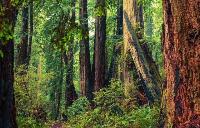
Pine Creek Trail
From the highway, turn down Kitamaat Village Road. At the bottom of the first hill, turn right onto a gravel road. The trail begins 700m from Kitamaat Village Road. Park at the creek and cross on foot until you see the trail sign. This hike is great for the whole family and takes about an hour in total. The trail is very scenic, with big cedars and streams, and you may even see some beaver activity.
Maggie’s Point
Maggie’s Point is a scenic and quick trail along the saltwater, which brings you to a gazebo. As you head towards Kitamaat Village, the turn off is on the right side of the road. Keep an eye out for a right turn-off just before you reach MK Bay Marina. The road leads to a small (emphasis on small) parking area where it leads in to the walking path. The path itself is quite easy, although there may be fallen trees across the path so please use caution. The path ends with a set of stairs leading up to a gazebo. Once there, enjoy the panoramic views of the Douglas Channel, as well as the natural wildlife which includes eagles, seals, whales and other marine life.
Giant Spruce Park
If you would like to visit what was once known as ‘BC’s largest living Sitka Spruce tree’, which is over 400 years old, then look no further. Turn left off of Haisla Blvd. by Rosario’s onto Kuldo Blvd. Take your first right onto Columbia Ave. and drive past the Riverlodge Recreation Centre. From there, follow the signs labelled ‘Giant Spruce’. Please use caution and watch for falling branches. This tree was once 165ft tall and measures 36.7ft in circumference. It is still truly a sight to see.
Joe’s Trail
Travel in Kitimat down Hwy 37S to Haisla Blvd. Turn left down Kuldo Blvd, right onto Columbia Ave. and travel until the road ends at the dyke. Turn right, take the first left onto a gravel road and drive about 1km and park near the Kitimat River. The trail is about an hour and a half hike through old growth forest. At the end, turn left, walk along the water to the dyke road, turn left again and walk along the road, before taking another left and making your way back to your vehicle.
Coho Flats / Fishermen’s Trail
A network of hiking paths that run between the Rod and Gun Club andthe Coho Flats area is a popular trail within city limits that leads to the Kitimat river. Fishermen’s Trail starts at the Rod and Gun Club, and eventually connects to the Coho Flats trail, which also reconnects back to ‘civilization’ on Baxter Avenue and has a path down to the river. Follow the trails far enough and you could end up at the golf course.
North Cove Trail
Drive past the Rio Tinto smelter, turn right onto Bish Forest Service road, and follow it for seven or eight kilometres. You’ll eventually see a sign for North Cove Trail. The trail follows a steep decline towards the water, where you’ll find a rustic picnic area and great views of the surrounding Douglas Channel. The hike is moderate with the climb up (it is all uphill on the way back) and goes for about one kilometre. Road access to the trail head was re-opened in recent years on a resurfaced gravel road. Be mindful that it’s an active forestry road, and there is one section of one-direction alternating traffic, so make sure to drive carefully.
Hirsch Creek Trails
Hirsch Creek Park has an easy set of four trails, a 1.5km loop, a 2km one-way, a 1.5km one-way and a 4km one-way. The park also has basic camping facilities. Families can simply pull into the park, turn right off the highway, just before the Hirsch Creek Bridge on the way into town. Watch for the trail signs in the park. On the opposite side of the highway, spectacular views await at the Hirsch Creek Canyon. This one is a 6km (approximately three hours) return trip, but again, the trail is an easy one, climbing only a 100 metres.
Mount Elizabeth
Looking for an even greater challenge? Then the steep and difficult Mount Elizabeth trail is for you. Drive north out of Kitimat for approximately 7.5km, then turn right, just south of where the transmission lines cross Hwy 37. Follow the gravel logging road for 13.5km. From there, a narrow 4WD road runs 2.5km to the trail head. A hike of 6km gets you to the alpine and panoramic views from what’s called Little Elizabeth. If you want to tackle the peak of Mount Elizabeth, it’s northwest of you, but be extremely cautious as you are now essentially mountaineering - you will be traversing an exposed ridge that is at points extremely narrow and hazardous. Therefore you are urged not to try for the peak unless properly equipped and the weather is absolutely clear, as the clouds can quickly sock in the mountain peak, making visibility challenging.
Robinson Ridge
Forest Avenue, which is the turn off to the Kitimat Visitor Info Centre, takes you to the Robinson Lake trail. After driving along that road for about 1.9km, turn right at the Wathl Mainline, heading south for 3.5km, to the trailhead. Rated moderate, the 4km trail takes you past a series of small lakes and coastal old growth forest. Hike time is about 5-7 hours. Although the last 1.5km can be very wet, most of that problem has been taken care of by the construction of a raised wooden walkway.
Clague Mountain If the views over the Kitimat Valley and Douglas Channel are what you seek, try the Clague Mountain trail (locals pronounce it Clack). Locals also refer to this as Squirrel Mountain. From the Service Centre, head north along Enterprise Avenue until you reach the gravel logging road. Follow that for about a kilometre then turn left and follow the side road 2km to the trail head. It’s a difficult 6km hike with a return time of 8-10 hours, but is well worth the Clague Mountain effort .
For more visit The Northern Sentinel.com.