The Douglas Channel on B.C.’s northern central coast is one of the most remarkable pieces of water on the continent. It is one of the largest and finest fjords and a gateway to some of the province’s greatest treasures.
For thousands of years the First Nations plied these protected inside waters in their large, finely crafted cedar canoes. These superb vessels, sometimes in excess of 16 metres in length, were capable of carrying the Haisla people’s full household possessions between their seasonal homes.
Trading, warring and cultural exchanges were all facilitated by the north-south corridor which Douglas Channel provided.
It was just over two centuries ago in 1789 that the European powers began probing these waters. The British and Spanish expeditions of captains George Dixon, James Colnett, Charles Duncan and Jacinto Camaano were all completed before 1792 when George Vancouver arrived.
There was a lot of interest at first in the lands adjacent to Douglas Channel. They thought that the mythical Northwest Passage route between the Atlantic and Pacific could start in this area.
Captains Vancouver and William Broughton, aboard HMS Chatham and HMS Discovery, searched right to the northern end of Douglas Channel.
Although they didn’t find what they were seeking, they did like what they saw.
Vancouver explored to the point where he could see clearly the channel ended and recorded seeing a wide, fertile green river valley emptying into an inner harbour on the eastern shore, now known as Minette Bay, and recognized the valley had a lot of potential.
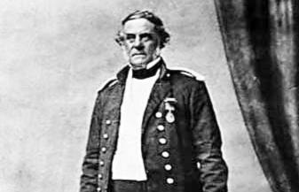
It wasn’t until the big surveys of the late 1800s when the idea of railway terminals was being considered, that this corridor was named by Dominion of Canada surveyors. From the Quadra expedition, official Louis Coste decided to name this fjord Douglas Channel in honour of B.C.’s first governor, Sir James Douglas.
The channel is five kilometres wide at some points and is nearly 60 kilometres in length to Wright Sound. From there it extends a further 20 kilometres south down Whale Channel to Ashdown Island making the full distance 80 kilometres.
Today names along the channel reflect the mix of European and First Nations backgrounds. Some features, like Emsley Cove, Bishop Bay and Raley Point, honour the missionaries while others recall the might of the British Empire and its sovereign, Queen Victoria.
Clio Bay, for example, was named for the 1,500 tonnes HMS Clio, a twenty-two gun Pearl-class Corvette. The Clio, with a steam engine and full sail rig, was dispatched to Kitamaat from Esquimalt in 1865 by Governor Douglas in response to a reported murder.
It pulled out all stops with a full cannonade in front of the village after which all the officers in full uniform came ashore to get to the bottom of the difficulties.
Douglas Channel landmarks with Haisla origins include Weewanie, Jesse, Gilttoyees and Bish. The name for Bish Creek has apparently strayed quite far from the original Haisla name of Beese.
Some of the legendary vessels which made the journey up Douglas Channel to Kitamaat Mission were the Hudson Bay Company vessels Beaver and Otter and the Union steamships Catella and Camosun.
Others included the Coquitlam, Chilliwack, Tees, Nell, Danube, Boscowitz, Queen City, Muriel, Willapa and Edith.
Then, of course, there was pioneer Minette Bay rancher Rudolph Braun who traded around the maritime northwest aboard his supply vessel the Minette and there were the mission boats Glad Tidings and Thomas Crosby.
In the beginning of the Alcan era, there were the Delta King, Norah, Northland Prince and Nechako. Among the vessels on the Douglas Channel these days are the Georgia Master and the two Kitimat Royal Canadian Marine Search and Rescue Station 63 vessels Alpha and Bravo (still affectionately but no longer officially known as the Snowflake Responder).
Coast Guard ships that visit regularly include the Gordon Reade, the Wilfred Laurier and Martha Black.
Some members of the Haisla Nation have commercial fishing boats while Kitimat’s guiding community routinely traverses the channel in all but the worst weather. And the port of Kitimat continues to attract freighters, tankers and barges of many descriptions from around the globe.
Douglas Channel has two principal harbours. At the north end is the port of Kitimat with its three industrial terminals, one on the western side at the main Rio Tinto Aluminum smelter, one in the centre serving the old Methanex methanol and Pacific Ammonia plants - now owned by LNG Canada, and the principal eastern site is the old Eurocan pulp and paper causeway with its more substantial dock system.
This dock now proudly displays the large Rio Tinto sign in red and white.
Kitimat currently has three dock and berthing spaces, one a smaller facility three kilometres to the northeast - the Minette Bay Marina tucked away at the end of shallow Minette Bay - the second a larger full-service marina at M.K. Bay owned by Kitamaat’s Haisla First Nation and the third a dock and collection of small vessels right at the south end of Kitamaat Village.
Douglas Channel’s second harbour is at Promise Island, nearly 60 kilometres south beside Wright Sound. Located at the small Tsimshian village of Hartley Bay, home to the Gitga’at people, it is Douglas Channel’s only other dock with facilities.
Overall, services in the area of Douglas Channel are few and far between so careful planning is required for all channel expeditions, especially those travelling beyond Hartley Bay to what’s called the outside waters.
In recent decades the natural wonders of Douglas Channel and Princess Royal Island, just 60 kilometres south of MK Bay Marina, have attracted international attention. Environmentalists are recommending Princess Royal become a great national park candidate, while prestigious organizations like National Geographic have featured stories on the natural wealth of Princess Royal and the Great Bear Rainforest.
Tour vessels like the Maple Leaf are catering to high-end adventure tourists who converge each fall on our channel hoping to witness the extraordinary phenomenon of humpback whales bubble net feeding. These islands are also home to B.C.’s iconic kermode bear.
Also known as the Spirit Bear, it is an all-white to almost cream coloured black bear. But it is not an albino, rather the colour difference is caused by a recessive gene - white bears can be born to an all-black mother and vice versa. Gribbel Island right next to Princess Royal has the largest concentration of kermode bears in the world.
The channel corridor has a lot to recommend, including five inviting hot springs which are among B.C.’s finest - three of them, Bishop Bay, Weewanie, and Europa, have park status. The corridor offers impressive rivers, reversible tidal inlet waterfalls, magnificent scenery and superlative fish and wildlife reserves and has been referred to as one of B.C.’s best and most overlooked kayak destinations.
What other areas could provide viewing of grizzly, black and kermode bears all in the same day?
Coastal wolves, often in the colour black, are also of great interest. Besides the humpback whale, there are also orca and fin whales with the fin whale, the world’s second largest creature, becoming more common in these waters in recent years.
All in all, Kitimat is truly the natural place to launch a top-notch wilderness adventure.