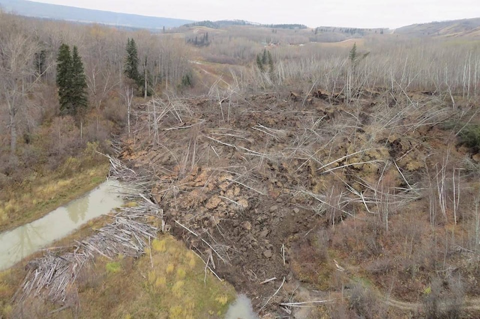
A report from British Columbia’s chief inspector of mines says the cause of a slow-moving landslide that has threatened a tiny B.C. community may never be determined.
The steep slope above Old Fort slumped over several days in 2018, tearing out the only road and prompting evacuations in the community of about 150 just outside Fort St. John.
The report, posted to the B.C. government website in October, says despite geotechnical assessments, the root cause of the slide remains “inconclusive.”
The first cracks in the earth were noticed in September 2018 at an active gravel pit at the top of the slope where work remains suspended after parts of it slipped 10 metres within hours.
The study says it’s not clear if a cause “will ever be determined with certainty,” but that the pit’s stockpile of gravel combined with natural slope instability and rain that was 44 per cent above average may all have been factors.
The report makes four findings, including one calling on the Ministry of Energy Mines and Petroleum Resources to issue an alert aimed at improving industry awareness of geohazard risks at other B.C. gravel pits, reminding them to consider and plan for those risks.
Owners of all but a handful of properties were allowed to return to Old Fort by late 2018, but slow-speed slumping resumed again this year, buckling the enclave’s only road for a second time and prompting evacuation alerts.
The ministry report does not address the latest slide.
Whatever changes occurred before the 2018 Old Fort slide, the report says it was enough to change the condition of a marginally stable Peace River Valley slope, resulting in the slide.
“Given the large volume of the slide, the small changes in topography that preceded it, and the lack of a clear and definitive event trigger, it is possible that if the slide had not occurred on September 29, 2018, it could have occurred at some future date — whether triggered by natural events or human activity,” the report says.
The Peace River Regional District said in June that information from technical specialists had determined “the risk to the community posed by the (2020) Old Fort slide movements is low.”
The district’s website shows six properties, or parts of properties, remain evacuated due to the original slide, more than two years after it happened.
The Canadian Press
Like us on Facebook and follow us on Twitter.
Want to support local journalism? Make a donation here.