By Walter Thorne
The Kitimat River is a remarkable glacier-fed Northwest Coast waterway. At nearly 100 kilometres in length with 29 tributary streams, the watershed carries millions of tons of sediment and water to the Douglas Channel every year.
Three tributaries - the 37 kilometre long Big Wedeene, the 34 kilometre Hirsch Creek and the 31 kilometre Chist Creek - are rivers in their own right. Many snowfields and at least two glaciers, the Davie and Wedeene, help sustain the flow even during summer droughts.
But when high water hits - usually in the fall or spring run off - the river quickly becomes dangerous. One early recorded fatality was that of Sam Henderson of Henderson Ranch, located near Maggie Point just north of the MK Bay Marina. He drowned while working on Herbert Clague’s up-river surveys in the early 1900s.
This river has provided for the Haisla for centuries and its waters, shores and forests have nurtured so many. Even explorer George Vancouver commented on the wide inviting splendour he witnessed.
Early settlers, loggers, miners, survey parties and politicians provided infrastructure in the valley corridor. The mail route of 1900 through to the Hazeltons included two crossings on cable lines, one at what is today the Cablecar sub-division and the other at Chist Creek further up the valley.
Through the years the Kitimat has been known as a superb river for fishing. The spring eulachon and summer salmon runs were large and healthy. There was even a Department of Fisheries watchman stationed on a floating facility at Minette Bay and valley pioneer Christel Braun recalls visiting watchman Cripes and sharing a crab feast.
Today the Kitimat River has one of the finest estuaries around with a classic fan-shaped delta and adjacent bay which provide more than 300 hectares of grasslands and sedges.
In a fisheries research report biologist Dawn Remington described the Kitimat estuary as one of Northwest B.C.’s most significant.
Kitimat’s salmon runs are world renowned, all five species of salmon plus steelhead drawing anglers from near and far. In 1984 hatchery staff netted and photographed one of their own fin-clipped chinooks weighing in at a fantastic 65 pounds.
No other hatchery could claim such a feat. And several wild chinooks have been recorded in at 76 pounds.
Valley pioneers say that in the years prior to widespread logging, gravel extraction and building of industrial corridors the river ran clearer even through high water events.
And there were not many floods even during prolonged deluges of rain. Early resident Ben Schwarz remembers drinking straight from the river and that there were fewer days when the waters turned brown with sediment.
But in the 1950s, 60s and 70s the Kitimat Valley saw an onslaught of development.
Kitimat’s riverside Sandhill became a giant mine site with conveyors going round the clock while the high pitched growl of chain saws reverberated through the valley.
And when the deluges came the river surged with sediment and debris. In the early years Alcan erected a river depth gauge near the Haisla Bridge. It was something akin to a giant thermometer in appearance. That lasted past 1963 when the federal government erected a hydrological measurement station near the current pumphouse. This station has provided data to us for the past 54 years.
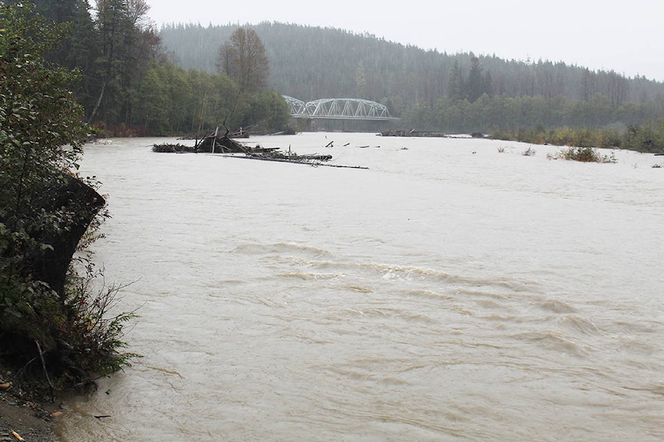
The Kitimat, like many coastal streams, has a huge rate of fluctuation.
At summer drought levels it can discharge as little as 18 cubic metres per second but in big flood events like 1966, 1978, 1992 and 2017 the raging river can see the flow rate surge to more than 3,500 cubic metres per second.
For the new town of Kitimat 1966 was perhaps the worst high water event. On October 27, after two days of heavy rain and melting snow, the river surged into Kitimat’s Service Centre and parts of Kildala. Much of the Service Centre water originated from Duck and Goose Creeks.
Water flooded several car dealers and there was even water in the lobby of the Kitimat Gordon Hotel. Max Patzelt, not wanting to miss the opportunity, staged a picture of a fellow standing at the bar fishing rod in hand.
That year resulted in many expensive insurance claims and soon after governments, including Kitimat Council, got busy on flood prevention plans.
In the following years millions were spent on studies, models and extensive rip rap bank stabilization and the installation of kilometres of dykes.
The perimeter of the service centre was dyked and so was the area of Kildala near Riverlodge. The dyking was further improved after the devastating floods in 1978 which nearly eclipsed 1966.
On that Halloween a record 179 mm of rain fell, which was added to by snowmelt. In town one section of dyke was breached, the highway between Kitimat and Terrace was washed out and on the road to Kitamaat Village the Wathl Creek bridge was lost - at least one vehicle was swept from that bridge into the Douglas Channel.
Even the Pacific Northern Gas pipeline was severed, leaving communities without heat for days. By 1982 Kitimat was better prepared with four kilometres of dyking standing guard against the menacing force of the river.
Throughout the ebb and flow of time our river’s Haisla Bridge has endured due in part to that dyking. Also the District of Kitimat pump station water infiltration wells have endured. But since the big landslide up Hirsch Creek turbidity has been an issue which, combined with more stringent standards, have necessitated boil water advisories occasionally.
The Kitimat is a river that naturally meanders, which if unchecked, would see it dramatically change course over the years. Recognising that as early as the 1950s, Alcan dyked and rip rapped parts of the river at the delta to guarantee stability for their transmission towers.
Further rip rapping and dyking occurred throughout the zone from the Rod and Gun down to the Lower Dyke where Eurocan Pulp and Paper had their mill outflow pipe.
The river bank control is also quite extensive near the various pump houses and Kitimat Hatchery. But all those measures didn’t prevent the near disastrous events which occurred when the river raged in September of 2017.
In the early morning of September 11 campers in Radley Park awoke to quite a sight: they were totally surrounded by the rising waters which were right up to their wheel axles. Across the river by the Giant Spruce the situation was worse with four vehicles, including a full-sized motor home, lost to the torrents.
One couple was extracted just in time via a Search and Rescue jet boat and another was plucked off the roof of their camper by helicopter. The rain was incredible at a near record 112 mms.
And unbelievably the situation nearly repeated itself just a month later on October 15-16 when more than 70 mms of rain and melting snow combined to cause the river to break its banks again.
While it is difficult to predict when flood events will occur, one thing is certain: it will rain and there will be water aplenty. And that despite the huge fluctuations in the river flow over time, the Kitimat will remain our best resource.